Iowa's Ecoregions
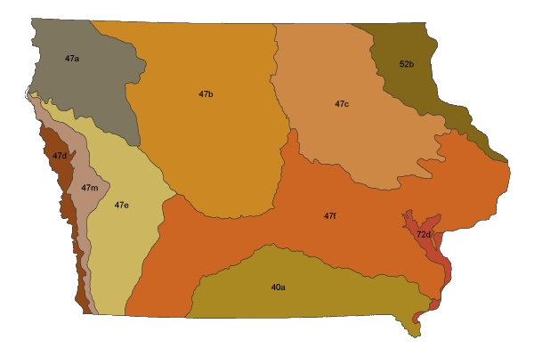
Ecoregions denote areas of general similarity in ecosystems and in the type, quality, and quantity of environmental resources.
An ecoregion is identified through patterns and composition of both biological and physical characteristics, including geology, physiography, vegetation, climate, soils, land use, wildlife, and hydrology.
The interactions and relative importance of each of these components varies between ecoregions, creating a unique ecosystem within each region.
Combined with a network of wadeable reference sites, ecoregions provide a framework for stream biological assessment, allowing researchers, watershed coordinators, and others interested in watershed improvement to make certain assumptions and predictions about the relative health of streams within an ecoregion.
There are 10 ecoregions and subecoregions within the state of Iowa:
Wadeable Reference Site FIBI Warm Water Results
| Eco Desig | Eco Name | Min | 25th Percentile | Mean | Median | 75th Percentile | Max | Total Samples |
|---|---|---|---|---|---|---|---|---|
| 40a | Loess Flats and Till Plains | 16 | 35 | 41.68 | 42 | 50 | 66 | 53 |
| 47a | Northwest Iowa Loess Prairies | 35 | 40 | 45.36 | 44 | 49 | 63 | 25 |
| 47b | Des Moines Lobe | 13 | 38 | 49.84 | 51 | 61 | 85 | 129 |
| 47c | Iowan Surface | 27 | 60 | 67.8 | 70 | 77 | 92 | 142 |
| 47d | Missouri Alluvial Plain | No reference sites | 0 | |||||
| 47e | Steeply Rolling Loess Prairies | 12 | 27.25 | 34.92 | 36 | 42 | 63 | 26 |
| 47f | Rolling Loess Prairies | 10 | 39.5 | 49.09 | 48 | 58 | 83 | 111 |
| 47m | Western Loess Hills | No reference sites | 0 | |||||
| 52b | Paleozoic Plateau (Driftless Area) | 9 | 47 | 55.41 | 53 | 63 | 91 | 118 |
| 72d | Upper Mississippi Alluvial Plain | 11 | 31 | 36.08 | 38 | 45 | 54 | 13 |
Wadeable Reference Site BMIBI Warm Water Results
| Eco Desig | Eco Name | Min | 25th Percentile | Mean | Median | 75th Percentile | Max | Total Samples |
|---|---|---|---|---|---|---|---|---|
| 40a | Loess Flats and Till Plains | 14 | 43 | 50.04 | 52 | 58 | 78 | 53 |
| 47a | Northwest Iowa Loess Prairies | 10 | 45 | 50.82 | 51 | 56 | 88 | 49 |
| 47b | Des Moines Lobe | 10 | 50 | 57.64 | 59 | 67 | 84 | 173 |
| 47c | Iowan Surface | 23 | 57 | 65.12 | 66 | 75 | 91 | 164 |
| 47d | Missouri Alluvial Plain | No reference sites | 0 | |||||
| 47e | Steeply Rolling Loess Prairies | 28 | 46.5 | 53.74 | 53 | 61.5 | 72 | 39 |
| 47f | Rolling Loess Prairies | 20 | 54 | 61.08 | 61 | 69 | 86 | 127 |
| 47m | Western Loess Hills | No reference sites | 0 | |||||
| 52b | Paleozoic Plateau (Driftless Area) | 52 | 62 | 70.55 | 70 | 78.5 | 87 | 55 |
| 72d | Upper Mississippi Alluvial Plain | 20 | 37.5 | 46.83 | 41 | 54.75 | 78 | 12 |
Wadeable Reference Site BMIBI Cold Water Results
| Eco Desig | Eco Name | Min | 25th Percentile | Mean | Median | 75th Percentile | Max | Total Samples |
|---|---|---|---|---|---|---|---|---|
| 47c | Iowan Surface | No reference sites | 0 | |||||
| 47f | Rolling Loess Prairies | No reference sites | 0 | |||||
| 52b | Paleozoic Plateau (Driftless Area) | 42 | 60 | 68.01 | 69 | 76 | 92 | 110 |